View USA Map

robogeo.com banner

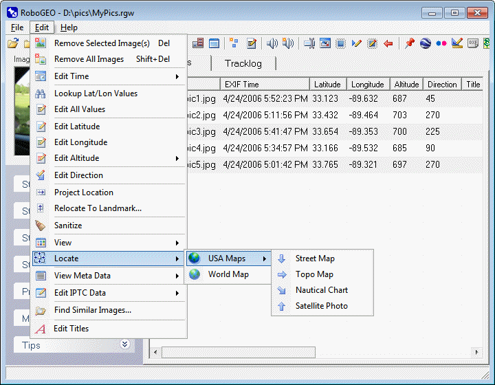
Locate Photo on USA Maps

click on 'File', 'Edit' or 'Help' to navigate the documentation
click on File, Edit and Help above to navigate
 

Once you select the images and geocode them, you can view the photo locations on a variety of maps. Alternatively, you can create a web page that uses Google Maps or Google Earth to show where your photos were taken. Using the Flickr2Map service provides similar functionality for Flickr photos.

You can also quickly preview an image location by selecting it and then pressing F5. This will load the Google Earth Geocoder.

These options are only available if the image location falls within the USA. If outside the USA, you can use Multimap's mapping server.

Street Map

View the image location on a street map using the U.S. Census Bureau's mapping server.

Topo Map

View the image location on a topo map at TopoZone.com.

Nautical Chart

View the image location on a nautical chart at Aeroplanner.com.

Satellite Photo

View the image location on a satellite photo at Microsoft's TerraServer.


© 2003-2008 Pretek, Inc.
File pull-down menu Edit pull-down menu Help pull-down menu Remove Selected Image Remove All Images Edit EXIF Time Lookup Latitude and Longitude Values Edit All Values Edit Latitude Edit Longitude Edit Altitude Edit Photo Direction Project Image Location View Image Locate photo on a map View EXIF Info View photo on USA maps View photo on a world map Street map Topo map Nautical chart Satellite photo